18 February 2023

A snapshot of biodiversity protection in Antarctica

figure 1

Abstract: "Threats to Antarctic biodiversity are escalating, despite its remoteness and protection under the Antarctic Treaty. Increasing human activity, pollution, biological invasions and the omnipresent impacts of climate change all contribute, and often combine, to exert pressure on Antarctic ecosystems and environments. Here we present a continent-wide assessment of terrestrial biodiversity protection in Antarctica. Despite Antarctic Specially Protected Areas covering less than 2% of Antarctica, 44% of species (including seabirds, plants, lichens and invertebrates) are found in one or more protected areas. However, protection is regionally uneven and biased towards easily detectable and charismatic species like seabirds. Systematic processes to prioritize area protection using the best available data will maximize the likelihood of ensuring long-term protection and conservation of Antarctic biodiversity."

Read More: https://www.nature.com/articles/s41467-019-08915-6

Effects of roads on giant panda distribution: a mountain range scale evaluation

figure 1

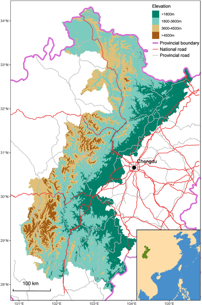
Abstract: "Few studies have focused on the mountain ranges scale effects of roads on wildlife. This lack of data could lead to an underestimation of the negative impact of roads on animal populations. We analyzed a dataset that included 74.4% of the giant panda population and covered 78.7% of the global giant panda habitat to estimate road-effect zones for major roads, and to investigate how these major roads influenced the distribution of giant pandas on a mountain range spatial scale. We found that the density of giant panda signs was significantly decreased by proximity to major roads. The effect zone reached 5,000 m from national roads and 1,500 m from provincial roads. Structural equation model analysis revealed that the strongest negative impact of major roads on giant pandas was via the reduction of nearby forest cover. The results should provide a better understanding of the impact of anthropogenic infrastructure and regional economic development on wildlife, thus providing a basis for conservation policy decisions. We suggest that the environmental impact assessment of proposed roadways or further researches on road ecological effects should expand to a larger scale and consider the possible habitat degradation caused by road access."

Read More: https://www.nature.com/articles/s41598-018-37447-0

Mapping the planet’s critical natural assets

figure 3

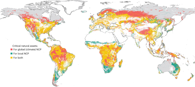
Abstract: "Sustaining the organisms, ecosystems and processes that underpin human wellbeing is necessary to achieve sustainable development. Here we define critical natural assets as the natural and semi-natural ecosystems that provide 90% of the total current magnitude of 14 types of nature’s contributions to people (NCP), and we map the global locations of these critical natural assets at 2 km resolution. Critical natural assets for maintaining local-scale NCP (12 of the 14 NCP) account for 30% of total global land area and 24% of national territorial waters, while 44% of land area is required to also maintain two global-scale NCP (carbon storage and moisture recycling). These areas overlap substantially with cultural diversity (areas containing 96% of global languages) and biodiversity (covering area requirements for 73% of birds and 66% of mammals). At least 87% of the world’s population live in the areas benefitting from critical natural assets for local-scale NCP, while only 16% live on the lands containing these assets. Many of the NCP mapped here are left out of international agreements focused on conserving species or mitigating climate change, yet this analysis shows that explicitly prioritizing critical natural assets and the NCP they provide could simultaneously advance development, climate and conservation goals."

Read More: https://www.nature.com/articles/s41559-022-01934-5

Potential impact on whales overlooked as deep-sea mining looks set to start, experts say

A pod of sperm whales.

Abstract: "Scientists say future deep-sea mining activities could impact cetaceans through noise pollution, which could interfere with their communication processes. According to an opinion piece, a team of experts say assessments of deep-sea mining impact have focused on species associated with the seabed rather than transitory megafauna that inhabit the proposed mining areas, and that urgent research is needed to understand the potential impact on cetaceans. However, a mining company says it is evaluating the potential impact of its proposed operations on cetaceans through the gathering of acoustic data during its recent mining test in the CCZ, which it will combine with three years of environmental baseline data. Deep-sea mining in international waters may begin later this year after the Pacific island nation of Nauru, which sponsors a subsidiary of a Canadian mining firm, requested accelerated approval of its mining operation."

Read More: https://news.mongabay.com/2023/02/potential-impact-on-whales-overlooked-as-deep-sea-mining-looks-set-to-start/

26 October 2022

Latest ‘plan for the planet’ calls for protecting 44% of land, home to 1.8b humans

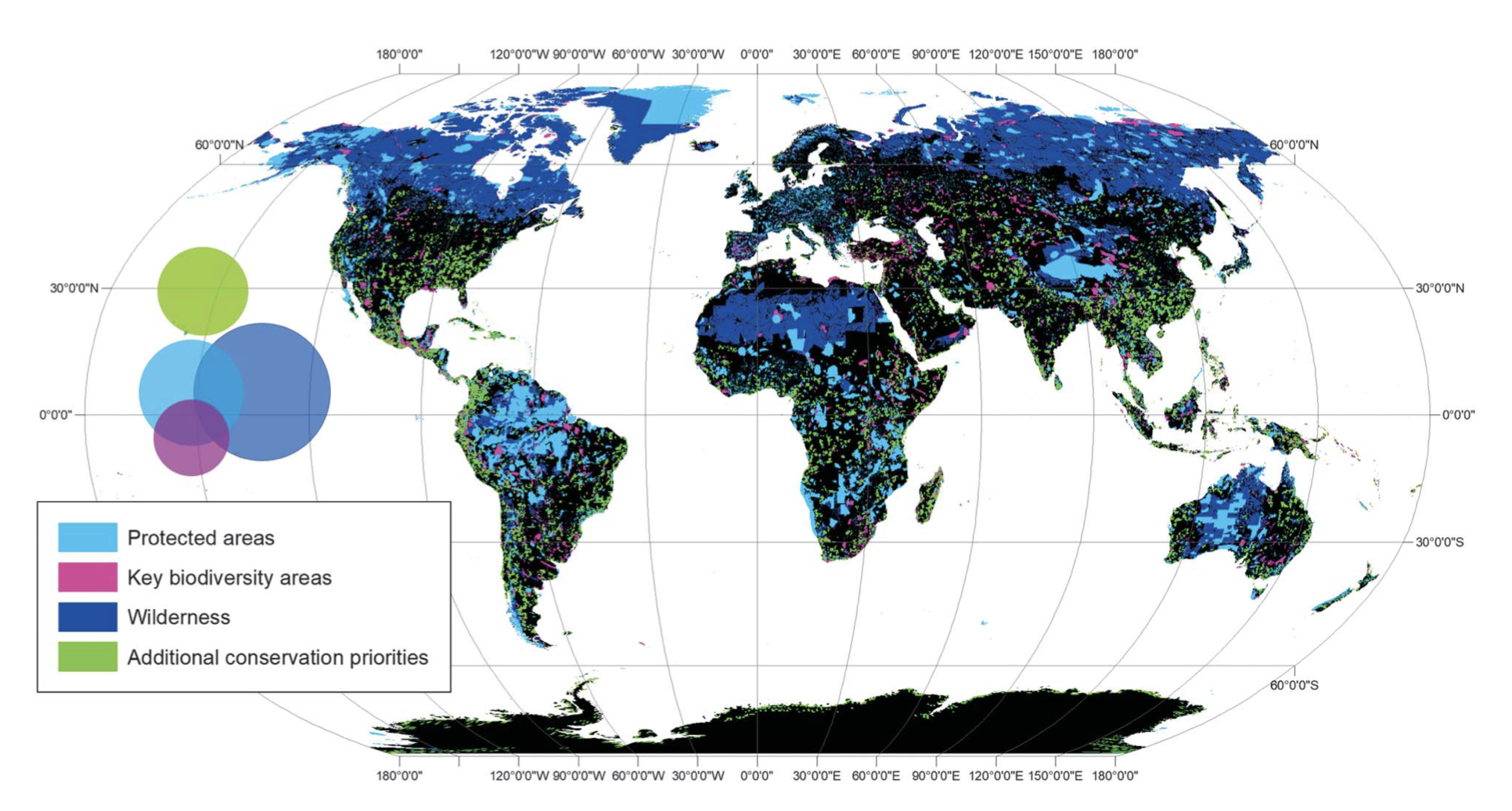
 Minimum land area for conserving terrestrial biodiversity. Components include PAs (light blue), KBAs (purple), and ecologically intact areas (dark blue). Where they overlap, PAs are shown above KBAs, which are shown above ecologically intact areas. New conservation priorities are in green. The Venn diagram shows the proportional overlap between features. Map courtesy of Allan et al.


Abstract: "A new study says 44% of Earth’s terrestrial area needs conservation attention to halt the runaway destruction of the natural world. The figure is significantly higher than the goal currently under discussion as part of the global post-2020 agenda, which is to protect 30% of land and ocean by 2030. The area identified for protection by the new study is home to 1.8 billion people, almost a quarter of the human population. The study authors suggest prioritizing biologically rich regions at the highest risk of being converted for human use by 2030, most notably in Africa."

Read More: https://news.mongabay.com/2022/06/latest-plan-for-the-planet-calls-for-protecting-44-of-land-home-to-1-8b-humans/

17 September 2022

Zero-deforestation commitments ‘fundamentally limited’ in tackling deforestation, study argues

Abstract: "Researchers found that while 90-99% of tropical deforestation in 2011-2015 was driven by agricultural industries, only 45-65% of the cleared land was actually used to grow crops or raise cattle. The rest of the cleared land was the result of activities such as speculative clearing and out-of-control agricultural fires, the study says. The researchers also concluded that because three-quarters of tropical deforestation is driven by domestic demand, corporate zero-deforestation pledges geared toward expert markets are limited in their ability to reduce this forest loss."

Read More: https://news.mongabay.com/2022/09/zero-deforestation-commitments-fundamentally-limited-in-tackling-deforestation-study-argues/

‘Mind-blowing’ marine heat waves put Mediterranean ecosystems at grave risk

Mediterranean coast.

Abstract: "A recent study reveals the widespread effects of climate change-driven marine heat waves on the ecological communities of the Mediterranean Sea. Rises in sea surface temperatures as high as 5° Celsius (9° Fahrenheit) above normal have caused die-offs in 50 different taxonomic groups of animals from around the Mediterranean Basin. These far-reaching impacts of the warming sea could devastate the fisheries on which many of the Mediterranean region’s 400 million people rely. Researchers advocate bolstering and expanding marine protected areas. Although they can’t hold back the warmer waters that have proven deadly to the sea’s rich biodiversity, these sanctuaries can help ensure that these species don’t have to cope simultaneously with other pressures, such as overfishing or pollution."

Read More: https://news.mongabay.com/2022/09/mind-blowing-marine-heat-waves-put-mediterranean-ecosystems-at-grave-risk/

Future reefs: A manifesto to save the world’s coral gardens

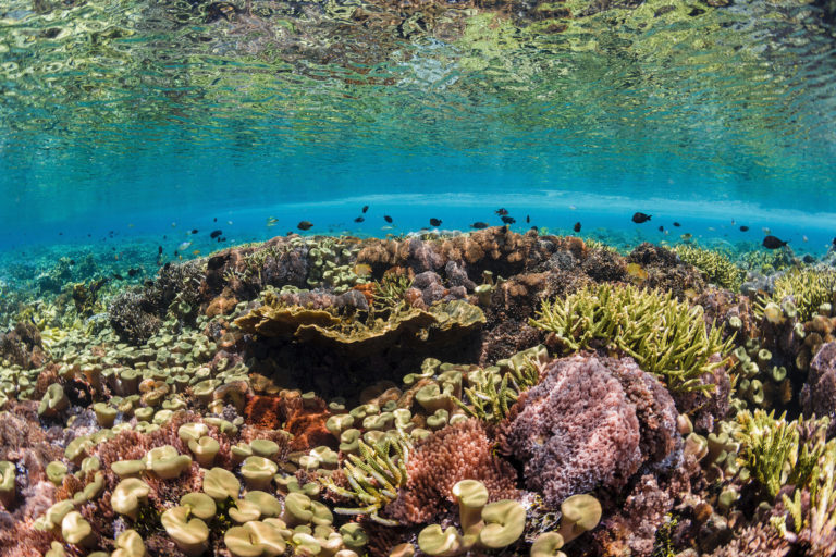
Coral reef in Indonesia

Abstract: "Coral reefs cover less than 3% of the ocean but contain a quarter of all marine life. Next to tropical rainforests, they are the most biodiverse ecosystems on Earth. Fifty of the world’s leading scientists recently laid out a roadmap to save the world’s coral reefs. With urgent climate action and by following this roadmap, these oases of beauty may retain critical marine biodiversity and provide a lifeline for coastal communities into the next century and beyond, a new op-ed argues."

Read More: https://news.mongabay.com/2022/09/future-reefs-a-manifesto-to-save-the-worlds-coral-gardens-commentary/

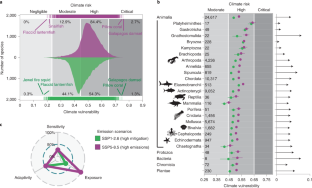
A Climate Risk Index for Marine Life

extended data figure 2


Abstract: "Climate change is impacting virtually all marine life. Adaptation strategies will require a robust understanding of the risks to species and ecosystems and how those propagate to human societies. We develop a unified and spatially explicit index to comprehensively evaluate the climate risks to marine life. Under high emissions (SSP5-8.5), almost 90% of ~25,000 species are at high or critical risk, with species at risk across 85% of their native distributions. One tenth of the ocean contains ecosystems where the aggregated climate risk, endemism and extinction threat of their constituent species are high. Climate change poses the greatest risk for exploited species in low-income countries with a high dependence on fisheries. Mitigating emissions (SSP1-2.6) reduces the risk for virtually all species (98.2%), enhances ecosystem stability and disproportionately benefits food-insecure populations in low-income countries. Our climate risk assessment can help prioritize vulnerable species and ecosystems for climate-adapted marine conservation and fisheries management efforts."

Read More: https://www.nature.com/articles/s41558-022-01437-y

07 July 2022

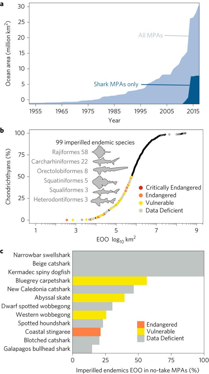
Global marine protected areas to prevent extinctions

figure 1


Abstract: "One goal of global marine protected areas (MPAs) is to ensure they represent a breadth of taxonomic biodiversity. Ensuring representation of species in MPAs, however, would require protecting vast areas of the global oceans and does not explicitly prioritize species of conservation concern. When threatened species are considered, a recent study found that only a small fraction of their geographic ranges are within the global MPA network. Which global marine areas, and what conservation actions beyond MPAs could be prioritized to prevent marine extinctions (Convention on Biological Diversity Aichi Target 12), remains unknown. Here, we use systematic conservation planning approaches to prioritize conservation actions for sharks, rays and chimaeras (class Chondrichthyes). We use chondrichthyans as they have the highest proportion of threatened species of any marine class. We find that expanding the MPA network by 3% in 70 nations would cover half of the geographic range of 99 imperilled endemic chondrichthyans. Our hotspot analysis reveals that just 12 nations harbour more than half (53) of the imperilled endemics. Four of these hotspot nations are within the top ten chondrichthyan fishing nations in the world, but are yet to implement basic chondrichthyan fisheries management. Given their geopolitical realities, conservation action for some countries will require relief and reorganization to enable sustainable fisheries and species protection."


Read More: https://www.nature.com/articles/s41559-016-0040

Identifying species threat hotspots from global supply chains

figure 1


Abstract: "Identifying hotspots of species threat has been a successful approach for setting conservation priorities. One important challenge in conservation is that, in many hotspots, export industries continue to drive overexploitation. Conservation measures must consider not just the point of impact, but also the consumer demand that ultimately drives resource use. To understand which species threat hotspots are driven by which consumers, we have developed a new approach to link a set of biodiversity footprint accounts to the hotspots of threatened species on the IUCN Red List of Threatened Species. The result is a map connecting consumption to spatially explicit hotspots driven by production on a global scale. Locating biodiversity threat hotspots driven by consumption of goods and services can help to connect conservationists, consumers, companies and governments in order to better target conservation actions."

Read More: https://www.nature.com/articles/s41559-016-0023

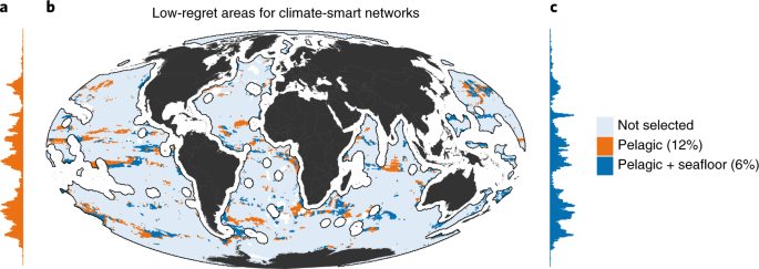
Towards climate-smart, three-dimensional protected areas for biodiversity conservation in the high seas

figure 3


Abstract: "Marine species are moving rapidly in response to warming, often in different directions and with variations dependent on location and depth. Given the current impetus to increase the area of protected ocean to 30%, conservation planning must include the 64% of the ocean beyond national jurisdictions, which in turn requires associated design challenges for conventional conservation to be addressed. Here we present a planning approach for the high seas that conserves biodiversity, minimizes exposure to climate change, retains species within reserve boundaries and reduces conflict with fishing. This is developed using data from across four depth domains, considering 12,932 vertebrate, invertebrate and algal species and three climate scenarios. The resultant climate-smart conservation areas cover 6% of the high seas and represent a low-regret option that provides a nucleus for developing a full network of high-seas marine reserves."

Read More: https://www.nature.com/articles/s41558-022-01323-7

Effects of roads on giant panda distribution: a mountain range scale evaluation

figure 1


Abstract: "Few studies have focused on the mountain ranges scale effects of roads on wildlife. This lack of data could lead to an underestimation of the negative impact of roads on animal populations. We analyzed a dataset that included 74.4% of the giant panda population and covered 78.7% of the global giant panda habitat to estimate road-effect zones for major roads, and to investigate how these major roads influenced the distribution of giant pandas on a mountain range spatial scale. We found that the density of giant panda signs was significantly decreased by proximity to major roads. The effect zone reached 5,000 m from national roads and 1,500 m from provincial roads. Structural equation model analysis revealed that the strongest negative impact of major roads on giant pandas was via the reduction of nearby forest cover. The results should provide a better understanding of the impact of anthropogenic infrastructure and regional economic development on wildlife, thus providing a basis for conservation policy decisions. We suggest that the environmental impact assessment of proposed roadways or further researches on road ecological effects should expand to a larger scale and consider the possible habitat degradation caused by road access."

Read More: https://www.nature.com/articles/s41598-018-37447-0

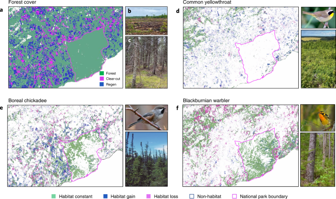
Forest degradation drives widespread avian habitat and population declines

figure 2


Abstract: "In many regions of the world, forest management has reduced old forest and simplified forest structure and composition. We hypothesized that such forest degradation has resulted in long-term habitat loss for forest-associated bird species of eastern Canada (130,017 km2) which, in turn, has caused bird-population declines. Despite little change in overall forest cover, we found substantial reductions in old forest as a result of frequent clear-cutting and a broad-scale transformation to intensified forestry. Back-cast species distribution models revealed that breeding habitat loss occurred for 66% of the 54 most common species from 1985 to 2020 and was strongly associated with reduction in old age classes. Using a long-term, independent dataset, we found that habitat amount predicted population size for 94% of species, and habitat loss was associated with population declines for old-forest species. Forest degradation may therefore be a primary cause of biodiversity decline in managed forest landscapes."

Read More: https://www.nature.com/articles/s41559-022-01737-8

02 February 2022

For the Year of the Tiger, a shared vision for the future of the iconic cat (commentary)

Abstract: "As the Year of the Tiger begins on February 1, a coalition of six top NGOs is committing to a cooperative approach to save the iconic big cat. In the past 12 years, tigers increased significantly in some areas but disappeared from others: a close assessment of these trends is key in advance of the next Global Tiger summit in September 2022. The authors from IUCN, FFI, WCS, WWF, Traffic and Panthera argue that ambition must increase but also that funders must support collaborative efforts instead of the status quo/competitive model of funding conservation."

Read More: https://news.mongabay.com/2022/01/for-the-year-of-the-tiger-a-shared-vision-for-the-future-of-the-iconic-cat-commentary/

Emphasizing declining populations in the Living Planet Report

figure 1

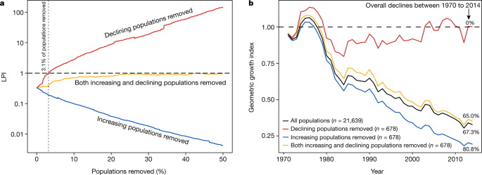
Summary: "The Living Planet Report, which has been published biannually since 1998, is key for understanding trends in wildlife populations and promoting sound conservation. Leung et al. recently disagreed with the conclusions of the Living Planet Report and found that the overall pattern of population declines stems from very few populations (extreme clusters), beyond which global vertebrate populations are not declining. However, when properly accounting also for the influence of the fastest-increasing populations, we find that the overall declines in the Living Planet Report are practically unchanged. Moreover, the Living Planet Database is heavily biased towards populations that receive more conservation attention, indicating that the true population trends are indeed dire and may actually be worse than depicted in the Living Planet Report.

Read more: https://www.nature.com/articles/s41586-021-04165-z

27 December 2021

Edward O. Wilson, prominent biologist and author, has died at 92

E. O. Wilson in 2003. Photo credit: Jim Harrison / PLOS

Abstract: "Edward O. Wilson, a prominent biologist and prolific author who help raise global awareness and understanding about biodiversity and conservation, has died. Wilson began his career studying the biology and social structures of ants which led him to develop expansive theories on evolution and humanity’s relationship with the planet. While Wilson’s research was highly influential in scientific circles and won numerous recognitions, he was mostly widely known for his accessible writing, including articles and best-selling books which introduced concepts like biodiversity to the masses. Wilson was an outspoken advocate for global conservation efforts."

Read more:  https://news.mongabay.com/2021/12/edward-o-wilson-prominent-biologist-and-author-has-died-at-92/

17 December 2021

‘Cooling the climate for 10,000 years’: How saving wetlands can help save the world

A cloudberry ripe for the picking in a Scandinavian bog. Image in the public domain.


ABSTRACT: "From the vast frozen mires of the arctic to the peat swamps of Asia: “all wetlands are under threat,” said Jane Madgwick, CEO of Wetlands International. “We’re losing them three times as fast as forests." Peat swamps, or peatlands, are particularly effective at storing carbon, which has accumulated over centuries and even millennia as dead plant matter became trapped in waterlogged soil. But if drained or otherwise damaged, peat quickly turns from carbon sink to carbon source. As nations race to protect and replant forests in an effort to curtail global warming, wetlands experts such as Madgwick are urging leaders to place similar importance on wetland conservation and restoration.


READ MORE: https://news.mongabay.com/2021/12/cooling-the-climate-for-10000-years-how-saving-wetlands-can-help-save-the-world/


Southeast Asian protected areas are effective in conserving forest cover and forest carbon stocks compared to unprotected areas

figure1


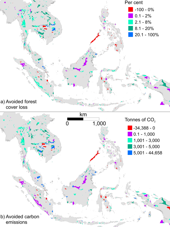
ABSTRACT: "Protected areas aim to conserve nature, ecosystem services, and cultural values; however, they have variable success in doing so under high development pressure. Southeast Asian protected areas faced the highest level of human pressure at the turn of the twenty-first century. To estimate their effectiveness in conserving forest cover and forest carbon stocks for 2000–2018, we used statistical matching methods to control for the non-random location of protected areas, to compare protection against a matched counterfactual. We found Southeast Asian protected areas had three times less forest cover loss than similar landscapes without protection. Protected areas that had completed management reporting using the Management Effectiveness Tracking Tool (METT) conserved significantly more forest cover and forest carbon stocks than those that had not. Management scores were positively associated with the level of carbon emissions avoided, but not the level of forest cover loss avoided. Our study is the first to find that METT scores could predict the level of carbon emissions avoided in protected areas. Given that only 11% of protected areas in Southeast Asia had completed METT surveys, our results illustrate the need to scale-up protected area management effectiveness reporting programs to improve their effectiveness for conserving forests, and for storing and sequestering carbon."

READ MORE: https://www.nature.com/articles/s41598-021-03188-w

28 September 2021

The first complete map of the world’s shallow tropical coral reefs is here

Branching coral

Abstract: "Scientists have completed the first-ever global, high-resolution map of the world’s shallow tropical coral reefs. When combined with an integrated tool that tracks global coral bleaching events in near-real-time, the new resource provides a comprehensive overview of the trends and changes in global coral reef health. While the completion of the map is an achievement in itself, the scientists behind the Allen Coral Atlas say they hope the new resource will spur action to improve coral reef protection. The new mapping platform is already being used to support conservation projects in more than 30 countries, including designation of marine protected areas and to inform marine spatial plans."

Read More: https://news.mongabay.com/2021/09/the-first-complete-map-of-the-worlds-shallow-tropical-coral-reefs-is-here/