14 May 2019

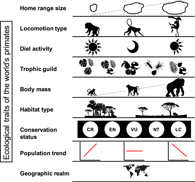
Ecological traits of the world’s primates

Figure 1


Abstract: "Ecosystems largely depend, for both their functioning and their ecological integrity, on the ecological traits of the species that inhabit them. Non-human primates have a wide geographic distribution and play vital roles in ecosystem structure, function, and resilience. However, there is no comprehensive and updated compilation of information on ecological traits of all the world’s primate species to accurately assess such roles at a global scale. Here we present a database on some important ecological traits of the world’s primates (504 species), including home range size, locomotion type, diel activity, trophic guild, body mass, habitat type, current conservation status, population trend, and geographic realm. We compiled this information through a careful review of 1,216 studies published between 1941 and 2018, resulting in a comprehensive, easily accessible and user-friendly database. This database has broad applicability in primatological studies, and can potentially be used to address many research questions at all spatial scales, from local to global."


Read More: https://www.nature.com/articles/s41597-019-0059-9


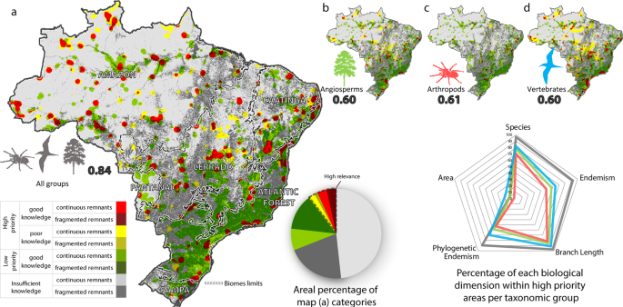
Modelling Highly Biodiverse Areas in Brazil

Figure 2


Abstract: "Traditional conservation techniques for mapping highly biodiverse areas assume there to be satisfactory knowledge about the geographic distribution of biodiversity. There are, however, large gaps in biological sampling and hence knowledge shortfalls. This problem is even more pronounced in the tropics. Indeed, the use of only a few taxonomic groups or environmental surrogates for modelling biodiversity is not viable in mega-diverse countries, such as Brazil. To overcome these limitations, we developed a comprehensive spatial model that includes phylogenetic information and other several biodiversity dimensions aimed at mapping areas with high relevance for biodiversity conservation. Our model applies a genetic algorithm tool for identifying the smallest possible region within a unique biota that contains the most number of species and phylogenetic diversity, as well as the highest endemicity and phylogenetic endemism. The model successfully pinpoints small highly biodiverse areas alongside regions with knowledge shortfalls where further sampling should be conducted. Our results suggest that conservation strategies should consider several taxonomic groups, the multiple dimensions of biodiversity, and associated sampling uncertainties."


Read More: https://www.nature.com/articles/s41598-019-42881-9

21 April 2019

Thermal-imaging system to estimate wildlife populations


Abstract: "A research team hailed a breakthrough in their imaging system’s ability to detect and identify orangutans in tropical rainforest. They now plan for computer algorithms to report back what a thermal camera has seen in real time. The researchers believe the system could also be used to spot poachers targeting rare species."


Read More: https://news.mongabay.com/2019/04/lift-off-for-thermal-imaging-system-to-estimate-wildlife-populations/


A composite measure of habitat loss for entire assemblages of species

Related image


Abstract: "Habitat destruction is among the greatest threats facing biodiversity, affecting common and threatened species alike. However, metrics for communicating its impacts typically overlook the non‐threatened component of assemblages. This risks the loss of habitat for species that comprise the majority of assemblages going unreported. Here, we adapt a widely‐used measure for summarizing researcher output (the h index) to provide the first metric describing natural habitat loss for entire assemblages, inclusive of threatened and non‐threatened species. For each of 447 Australian native terrestrial bird species, information on their association with broad vegetation groups was combined with distributional range maps to identify the difference between the estimated pre‐European and current extents of potential habitat. From this, we calculated the ‘Loss Index’ (LI), which reveals that 30% of native birds have each lost at least 30% of their potential natural habitat—an LI of 30. At the sub‐continental scale, the LI ranges from 15 in arid Australia to 61 in the highly transformed south‐east of the country. Further, different subcomponents of the assemblage have different LI values; for example, Australia's parrots ( n=52 species) have an LI of 38, while raptors ( n=32 species) have an LI of 25. The LI is simple to calculate, and can be determined using readily available spatial information on species distributions, habitat associations and human impacts on natural land cover. This metric, including the curves that are used to deduce it, could complement other biodiversity indices by being used for regional and global biodiversity assessments, comparing the status of natural habitat extent for assemblages within and among nations, monitoring changes through time, and forecasting future changes to guide strategic land use planning. The LI is an intuitive tool with which to summarise and communicate how human actions affect whole assemblages, and not just those that species identified as threatened."


Read More: https://onlinelibrary.wiley.com/doi/abs/10.1111/cobi.13331

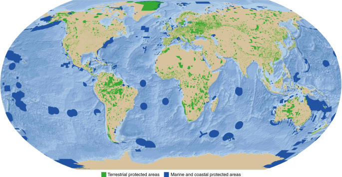
Sixty years of tracking conservation progress using the World Database on Protected Areas

Figure 1


Abstract: "The world’s protected area network is constantly changing, and the dynamics of this network are tracked using the World Database on Protected Areas (WDPA). This database evolved from a list of protected areas first mandated by the United Nations in 1959, and it now informs the key indicators that track progress toward area-based conservation targets. In this capacity, the WDPA illuminates the role of protected areas in advancing a range of international objectives and agreements, including the Convention on Biological Diversity and the Sustainable Development Goals. Despite ongoing challenges in maintaining such a complex global dataset, the WDPA is continuously improving and taking advantage of new technology, making it widely applicable to diverse users, including those in sectors far from its original intended audience. In the future, the WDPA will expand to include areas that contribute to conservation and sustainable use outside of formal protected areas, and will increasingly link to other key global datasets. These innovations in the way the WDPA is managed and used will deliver vital knowledge to support a sustainable future for biodiversity and people globally."


Read More: https://www.nature.com/articles/s41559-019-0869-3

17 March 2019

New MPA established in Philippines includes community-led monitoring program


Abstract: "A new marine protected area (MPA) has been founded in the Philippines within what are considered some of the most biologically diverse waters on Earth. The new MPA, which has been given the name Pirasan, encompasses more than 54 acres (about 22 hectares) of thriving coral reef habitat. The MPA was designed to protect this pristine reef system and, at the same time, boost an emerging local ecotourism industry. In addition to establishing the new protected area, the municipality of Tingloy has committed to a uniquely ambitious two-year program to monitor the reef’s health and empower local residents as stewards of the reef."


Read More: https://news.mongabay.com/2019/03/new-mpa-established-in-philippines-includes-community-led-monitoring-program/

01 March 2019

Master Regulators: How Mountain Lions Boost Biodiversity


"Mountain lions and wolves have suffered from our ignorance ever since pioneers inundated their wilderness homes. But an emerging view of mountain lions’ unique ecological role is coming into focus."


Read More: http://www.pbs.org/wnet/nature/blog/master-regulators-how-mountain-lions-boost-biodiversity/? fbclid=IwAR0LTHUeNz53iBixlHHCAEGjRYho-V8M_vcuXjLPjsLnuaF9HHn9DMCPCSA