24 November 2018

Map pinpoints ‘last chance’ locations of endangered species


Abstract: "A new assessment updates the last known ranges for nearly 1,500 species of animals and plants at 853 locations around the world. The three-year effort is aimed at helping scientists, governments and conservationists identify the threats that could lead to the extinction of these species and find ways to address them. Governments are already using this information to identify target areas for conservation to protect the last remaining habitats of threatened species. Nearly half of the sites identified lack formal protection, despite many of them having been flagged as important more than a decade ago."

Read More: https://news.mongabay.com/2018/11/map-pinpoints-last-chance-locations-of-endangered-speciesnearly-half-are-unprotected/


Changes in human footprint drive changes in species extinction risk

Figure 6


Abstract: "Predicting how species respond to human pressure is essential to anticipate their decline and identify appropriate conservation strategies. Both human pressure and extinction risk change over time, but their inter-relationship is rarely considered in extinction risk modelling. Here we measure the relationship between the change in terrestrial human footprint (HFP)—representing cumulative human pressure on the environment—and the change in extinction risk of the world’s terrestrial mammals. We find the values of HFP across space, and its change over time, are significantly correlated to trends in species extinction risk, with higher predictive importance than environmental or life-history variables. The anthropogenic conversion of areas with low pressure values (HFP < 3 out of 50) is the most significant predictor of change in extinction risk, but there are biogeographical variations. Our framework, calibrated on past extinction risk trends, can be used to predict the impact of increasing human pressure on biodiversity."


Read More: https://www.nature.com/articles/s41467-018-07049-5


Compensatory conservation measures for an endangered caribou population under climate change

Figure 1

Abstract: "Future human land use and climate change may disrupt movement behaviors of terrestrial animals, thereby altering the ability of individuals to move across a landscape. Some of the expected changes result from processes whose effects will be difficult to alter, such as global climate change. We present a novel framework in which we use models to (1) identify the ecological changes from these difficult-to-alter processes, as well as (2) the potential conservation measures that are best able to compensate for these changes. We illustrated this framework with the case of an endangered caribou population in Québec, Canada. We coupled a spatially explicit individual-based movement model with a range of landscape scenarios to assess the impacts of varying degrees of climate change, and the ability of conservation actions to compensate for such impacts on caribou movement behaviors. We found that (1) climate change impacts reduced movement potential, and that (2) the complete restoration of secondary roads inside protected areas was able to fully offset this reduction, suggesting that road restoration would be an effective compensatory conservation action. By evaluating conservation actions via landscape use simulated by an individual-based model, we were able to identify compensatory conservation options for an endangered species facing climate change."

Read More: https://www.nature.com/articles/s41598-018-34822-9


09 November 2018

Population estimates of Bornean orang-utans using Bayesian analysis at the greater Batang Ai-Lanjak-Entimau landscape in Sarawak, Malaysia

Image result for photo orangutan


Abstract: "The integration of Bayesian analysis into existing great ape survey methods could be used to generate precise and reliable population estimates of Bornean orang-utans. We used the Marked Nest Count (MNC) method to count new orang-utan nests at seven previously undocumented study sites in Sarawak, Malaysia. Our survey teams marked new nests on the first survey and revisited the plots on two more occasions; after about 21 and 42 days respectively. We used the N-mixture models to integrate suitability, abundance and detection models which account for zero inflation and imperfect detection for the analysis. The result was a combined estimate of 355 orang-utans with the 95% highest density interval (HDI) of 135 to 602 individuals. We visually inspected the posterior distributions of our parameters and compared precisions between study sites. We subsequently assess the strength or reliability of the generated estimates using identifiability tests. Only three out of the seven estimates had <35% overlap to indicate strong reliability. We discussed the limitations and advantages of our study design, and made recommendations to improve the sampling scheme. Over the course of this research, two of the study sites were gazetted as extensions to the Lanjak-Entimau Wildlife Sanctuary for orang-utan conservation."


Read More: https://www.nature.com/articles/s41598-018-33872-3

Modelling Dolphin Distribution to Inform Future Spatial Conservation Decisions in a Marine Protected Area

Figure 1


Abstract: "As marine predators experience increasing anthropogenic pressures, there is an urgent need to understand their distribution and their drivers to inform spatial conservation planning. We used an ensemble modelling approach to investigate the spatio-temporal distribution of southern Australian bottlenose dolphins (Tursiops cf. australis) in relation to a variety of ecogeographical and anthropogenic variables in Coffin Bay, Thorny Passage Marine Park, South Australia. Further, we evaluated the overlap between current spatial management measures and important dolphin habitat. Dolphins showed no distinct seasonal shifts in distribution patterns. Models of the entire study area indicate that zones of high probability of dolphin occurrence were located mainly within the inner area of Coffin Bay. In the inner area, zones with high probability of dolphin occurrence were associated with shallow waters (2–4 m and 7–10 m) and located within 1,000 m from land and 2,500 m from oyster farms. The multi-modal response curve of depth in the models likely shows how the different dolphin communities in Coffin Bay occupy different embayments characterized by distinct depth patterns. The majority of areas of high (>0.6) probability of dolphin occurrence are outside sanctuary zones where multiple human activities are allowed. The inner area of Coffin Bay is an important area of year-round habitat suitability for dolphins. Our results can inform future spatial conservation decisions and improve protection of important dolphin habitat."


Read More: https://www.nature.com/articles/s41598-018-34095-2


A Global Test Of Ecoregions

Figure 3


Abstract: "A foundational paradigm in biological and Earth sciences is that our planet is divided into distinct ecoregions and biomes demarking unique assemblages of species. This notion has profoundly influenced scientific research and environmental policy. Given recent advances in technology and data availability, however, we are now poised to ask whether ecoregions meaningfully delimit biological communities. Using over 200 
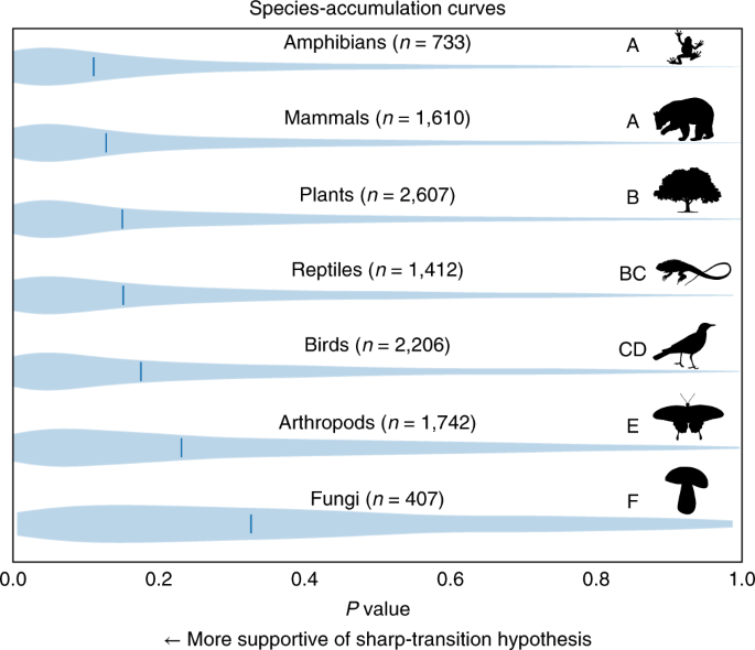
million observations of plants, animals and fungi we show compelling evidence that ecoregions delineate terrestrial biodiversity patterns. We achieve this by testing two competing hypotheses: the sharp-transition hypothesis, positing that ecoregion borders divide differentiated biotic communities; and the gradual-transition hypothesis, proposing instead that species turnover is continuous and largely independent of ecoregion borders. We find strong support for the sharp-transition hypothesis across all taxa, although adherence to ecoregion boundaries varies across taxa. Although plant and vertebrate species are tightly linked to sharp ecoregion boundaries, arthropods and fungi show weaker affiliations to this set of ecoregion borders. Our results highlight the essential value of ecological data for setting conservation priorities and reinforce the importance of protecting habitats across as many ecoregions as possible. Specifically, we conclude that ecoregion-based conservation planning can guide investments that simultaneously protect species-, community- and ecosystem-level biodiversity, key for securing Earth’s life support systems into the future."

Read More: https://www.nature.com/articles/s41559-018-0709-x